


Bjelasica - Zekova glava (Pešića jezero)
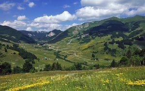
Mountain Bjelasica is for sure one of the most beautiful mountain ranges of Montenegro. It is located in the hearth of central continental region of Montenegro. It is evenly branched in all four directions, forming the shape of circle, with the length and width of 30km. The mountain Bjelasica range stretches over and area of 630 square km. River Lim from the east, Tara from the west, and Ljubivođa and Lepenica from the north, almost idealy delineate this mountain range. It is characterized by three important characteristics and comparative advantages: easy mobility and accessibility to the highest mountain peaks, great wealth of forest reserves, and abundance of aquatic systems. It's geological features are of volcanic origins, with smooth round shapes, differing from most other Montenegro mountains which are calcareous composition abounding in karst forms, with numerous crevasses and crevices. Therefore her summers are green and winters are white. While on Durmitor and Lovćen all the water goes underground, here it stays on the surface, interflowing in numeruous streams and rivers. Bjelasica lacks alpine climbing rocks but the vast spaciousness of it's mildly rolling landscapes composed of hills and peaks is amazing. This is the most green mountain in Montengro.
One part of the marked Montenegrin Climbing Transversal CT-1 goes across Bjelasica. Bjelasica mountain range has 10 peaks above 2000m elevation. Three highest peaks are: Crna Glava (2.139m), Zekova Glava (2.117m) and Troglava (2072m), hovering above beautiful Pešića jezero (1.820m). Also six glacial lakes are located here:
- Biogradsko Jezero (1.094m); Surface=44ha; Depth=12m
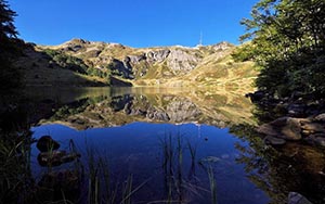
- Pešića Jezero (1.820m); Surface=3.74ha; Depth=8.4m
- Ursulovačko Jezero (1.895m); Surface=1.22ha; Depth=8.0m
- Šiško Jezero (1.660m); Surface=2.9ha; Depth=3.2m
- Malo Šiško Jezero (1.780m); Surface=0.62ha; Depth=1.7m
- Malo Ursulovačko Jezero (Blatina, 1.760m); Surface=0.5ha; Depth=2.2m
In the 1872. Montenegrin King Nikola had realized that Biogradska gora (Biograd's mountain) was the great ecological heritage for the future generations and protected it by the law. This is the one of the last three rainforests in Europe, with the typical rainforests vegetation. Eighty percents of this area is covered with forest, with trees as old as 500 years. There are 26 plant ecosystems, 86 kinds of trees and over 220 various plants. The one hundred old trees are 40 - 50m high. There are typical mountain trees: the oak, the maple, the beech, the fir, etc. The birds’ observers and ornithologists can enjoy the flights of eagles and 150 other birds. The Biograd's woods is the home of bears, wolves, dears, foxes, etc. There are over 350 kinds of insects.
Photo gallery
Surroundings
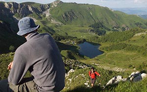
Zekova glava is surrounded with stunning scenery, composed of many mountain peaks that surrounds it. Viewpoint from the top provides one of the best views on Pešića jezero. There are many visible mountain peaks, of which the most iteresting are Vasojevički Kom (2.461m) i Kučki Kom (2.487m), Bobotov kuk na Durmitoru (2.523m), Hajla i Moračke planine.
- Zlatar (Velika Krševa peak) 1.626m; Distance: 60km
- Golija (Jankov Kamen) 1.833m; Distance: 70km
- Hajla 2.403m; Distance: 38km
- Đeravica (Serbian Prokletije) 2.656m; Distance: 50km
- Visitor (Plana peak) 2.211m; Distance: 32km
- Prokletije (Maja Jezerce peak) 2.694m; Distance: 47km
- Komovi (Kom Kulčki peak) 2.487m; Distance: 21km
- Moračke planine (Kapa Moračka) 2.226m; Distance: 45km
- Durmitor (Bobotov Kuk peak) 2.523m; Distance: 26km
- Maganik (Međeđi peak) 2.139m; Distance: 52km
- Ljubišnja (Dernjecista peak) 2.238m; Distance: 70km
- Sinjajevina (Babji Zub peak) 2.277m; Distance: 37k
See also ...
360° panorama of Pešića jezero
360° panorama panorama of Pešića jezero (diferent angle)
360° panorama panorama road towards Jelovica
Map
See M4 - Zekova glava on larger map kml
How to get there
Best way to start climbing to Zekova glava (2.117m) is Jelovica. You can get to it with by car from Andrijevica, heading towards Berane trough regional road. Just after Berane, in Pešca(A), turn left and continue along quality asphalt road all the way to Jelovica.
Climbing
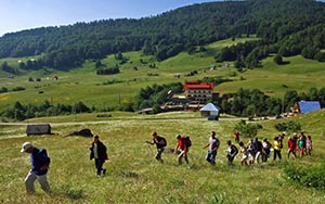
Upon arrival at the Jelovica you have more ways to chose to get to Zekova glava (2.117m). We recommend going via macadam road, which starts on the right side(B), located just 2km before the end of the asphalt road. This macadam road leads you to Pešića jezero, and then via walking path to Zekova glava. It is mainly moderate slope trail leading trough wonderful vegetation mainly trough beech and larch forest. You will also come across some streams and forest fruits. The way back leads trough meadow landscape interspersed with forest.
When to climb
Recommended time for climbing is end of May to middle of September. Climbing is possible during whole year, but for winter months you should have a lot of experience, warm clothes and winter footwear.
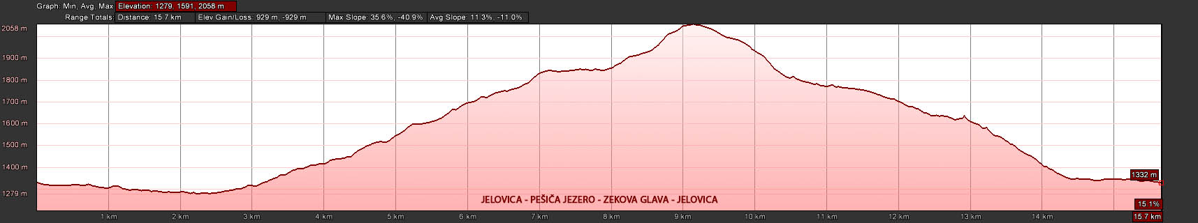
Elevation profile