


Prokletije - Volušnica
"The most inexplicable, the most unapproachable and the wildest mountain range on Balkan peninsula and, after Alps, in Europe. Southern Alps of Europe!" – said travel writer Ami Boue for Prokletije. Describing the mountain geographer Jovan Cvijić said - "Nowhere in the Balkan the glaciers have a left such a deep trail of their erosion as in Prokletije mountain range. After Alps, this was the most glacial mountain in Europe". Prokletije is surely one of the last mountains in Europe that has not been discovered entirely yet, one of the most enclosed, most reserved and most romantic places in Europe.
The Alps, the Dinaric Alps and the Prokletije Ranges represent a unique mountain system made by a folding action of the African plate which is under the European one. This process is visibly evident also by the constant listing of the Adriatic coast. The Dinaric Alps, 1000 km long, follow the direction of the Adriatic Sea and at their northwest and southeast ends formed the 'aggregates' of the Alps and the Prokletije massif. The massifs and aggregates that formed are very tall. The French travel writer Ami Boue was right when he called the Prokletije - "The Southern Alps". Many geographers today consider the Prokletije as a continuation of the Dinaric Alps. The name "Prokletije" (meaning "The Damned Mountains"), probably describe the cruelty of these mountains and the hard life of those who live in their vicinity. Recently, since 2009, most of the Prokletije massif located in Montenegro has been declared “national park Prokletije” (166km²).
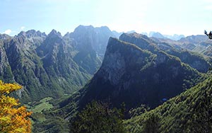
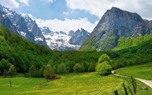
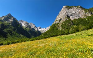
Volušnica (read "Volushnica") peak doesn’t belong to the group of highest peaks of Prokletije, but it's 600m high southern wall is still very amazing, dominating above beautiful Grebaja Valley. Volušnica and Popadija peaks are also widely known as maybe one of the best viewpoints peaks in this area, with views on amazingly beautiful peaks of Karanfili (2.460m, 2.490m, 2.441m), Očnjak (2.185m), Grebaja valley and other sharp peaks of Prokletije massif.
Volušnica peak is for sure an extraordinary mountaineering adventure, pure paradise for those who like impressive mountain scenery, especially for mountain photographers. Early morning or afternoon is optimal timing for taking shots because of the sun movement from the east to west. Although not the highest peak, this tour can be a good preparation for other, higher and more difficult peaks in the vicinity. Volušnica definitely offers highest enjoyment and leaves amazing impressions!
Photo gallery
Surroundings
After reaching the top, you are rewarded with a surprise. View from here provides a chance to experience Prokletije in the best possible way. You are surrounded with numerous wonderful peaks from every side. Most interesting ones are: Kolac (Kolata, 2.528m), Karanfili (2.460m, 2.490m, 2.441m), Maja Jezerce (2.694m) and Popadija (2.057m). You can also see mountain Visitor (2.211m) and Đeravica (2.656m), and nearby places Gusinje and Vusanje. In more detail:
SE: Kolac (Kolata, 2.528m), Rosni Vrh (Maja Rosit, 2.525m), Karanfili (2.460m, 2.490m, 2.441m), Maja Lagojvet (2.466m), Maja Vukoces (2.450m), Forca (2.340m), Maja Haruses (2.424m) and Maja e Pecmaras
S: Maja Jezerce (2.694m), Maja Popluks (2.569m), Kokervhake (2.508m), Maja Grik e Halt (2.625m), Maja Radohines (2.570m), Maja Brijaset (Brijac, 2.567m), Maja Hekurave (2.561m), Majet e Zabores, Maja Malisores (2.490m), Maja Shchokishte (2.461m), Sev i Barde (2.252m), Maja Ragomit (2.472m), Maja Alis (2.422m), Maja Snikut (Nikacki Vrh, 2.554m), Maja Skurt (2.499m), Vojusa (Vojusit, 2.210m)
N: Popadija (2.057m), Karaula (1.915m), Rogopec (Vezirova Brada, 1.780m), Gusinje town
NE: Visitor (2.211m) E: Đeravica (2.656m)&Bogdas (2.530m)(two peaks of Serbian part of Prokletije), Mt Bor and Vusanje village
See also ...
Nenad Filipović photo story about climbing to Prokletije
Photo gallery of Ribo Raičević
360° panoramas: Katun Volušnica, pogled sa Volušnice, Volušnica, pogled na Popadiju, pogled sa Popadije, Popadija, pogled sa Popadije, put između Volušnice i Popadije
Map
View M7 - Volušnica on larger map kml
How to get there
This tour starts at the valley of Grebaje (1.160m), which is accessible by car. To get to it, head down the regional road from Andrijevica towards Plav (25km), then towards Gusinje (13km). After, from Gusinje, there is a narrow asphalt road (7km) that leads you to Greabje, just underneath the slopes of Prokletije.
Climbing
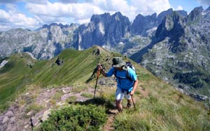
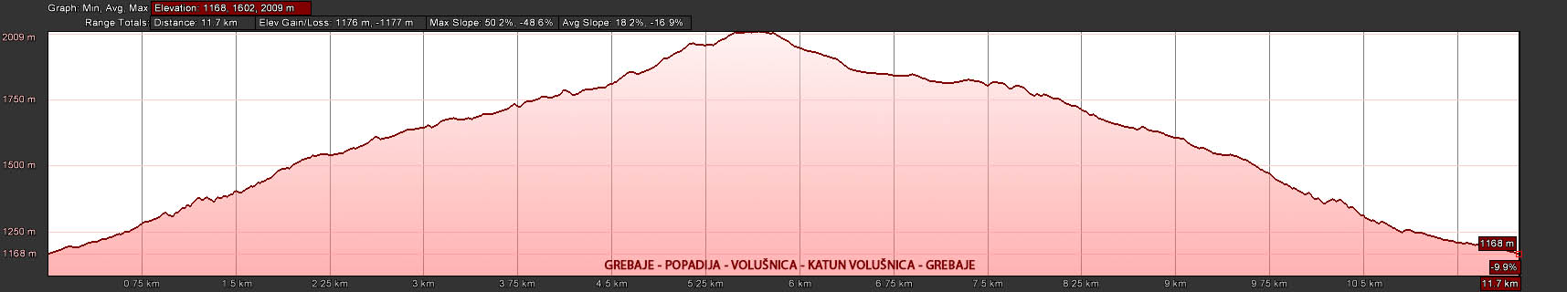
Marked hiking trail starts from Grebaja valley, from the local mountain home (1.160m). Trail leads trough beech forest to the plateau where katun (mountain village) Volušnica (1.680,) is located. Katun is built on glacial circle and it is rich with water. You need at least 2:00h to climb to it. From there you can choose to go to Volušnica (1.879m) or Popadija (2.057). Trail goes trough rocky but mainly grassy slopes. These two peaks are connected with trail, so you can visit both. The time needed to get from Volušnica to Popadija is 1:30h.
When to climb
Preferred time for climbing is beginning of Jun until end of September. You can expect ideal conditions by beginning of June because of the green vegetation and very good weather conditions. Even in Jun and July you can expect to find snow in the hollow slopes, but that is not interfering with climbing. If you decide to climb in April or May, it is strongly recommended to have winter equipment, especially footwear with crampons. It is possible to climb during whole year, but winter months require complete extreme winter equipment.
Elevation profile